Welcome to Old Pueblo 50 Mile Endurance Run!
Saturday, March 5, 2016 - 6:00 am
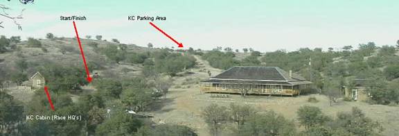
Start and Finish at Kentucky Camp
You will experience some of the most beautiful and rugged country in Southern Arizona and get a taste of the old west. Please be sure you are well-trained for the hills, rocks and remote nature of the event. The detailed map included with your packet, should be studied before race day and carried with you during the race.
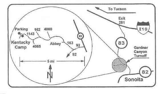
The course start and finish is at the Historic Mining Site of Kentucky Camp which is approximately 1 hour and 20 minute drive from central Tucson. It is approximately a 20 minute drive from Sonoita, and approximately a half hour drive from Patagonia.
To get to Kentucky Camp from the north (Tucson), take Interstate 10 east to Exit 281 (Highway 83, Sonoita). Head south on Exit 281 and follow State Route 83 approximately 20 miles to the Gardner Canyon Road Kentucky Camp sign and turn right (west). Stay on FS road 163 all the way , following the signs to Kentucky Camp.
To get to Kentucky Camp from the south (Sonoita or Patagonia), take State Route 83 north from Sonoita approximately 4 miles and turn left (west) on the Gardner Canyon Road. From the Gardner Canyon Road, go 0.7 miles to first intersection and turn right on Forest Service Road 163 following the signs to Kentucky Camp. Stay on FS road 163 all the way to Kentucky Camp.
When you get to Kentucky Camp, parking is at the gate above the building site. Don’t drive through the gate. Walk through the gate and down the hill to Kentucky camp, about ¼ mile.
Kentucky Camp (Start/Finish)
A challenging 50 mile course consisting of two 25 mile loops starting and ending at Kentucky Camp on forest service roads and trails through the southeastern part of the Santa Rita Mountains (part of the Arizona Trail). Elevation at Kentucky Camp (Start/Finish): 5142 ft, High point in course: 6232 ft
Pre-race Packet Pick-up will be held on 2/28/16 at Summit Hut, 5251 E. Speedway, Tucson, AZ 85712 from 1:00 to 4:00 pm. Packets can also be picked up Friday evening 3/4/16 from 6:00 to 7:00 pm at Kentucky Camp and race morning from 5:00 to 5:45 am. at Runner Check-In.
Race morning runner check in will be at Kentucky Camp from 0500am-0545am. If you have not picked up your race packet prior to race day, you will receive your packet and wristband at Runner Check In.
ALL RUNNERS MUST CHECK IN AND RECEIVE THEIR WRISTBAND. EVEN IF YOU ALREADY HAVE YOUR BIB #. IF YOU START RACE WITHOUT WEARING YOUR WRISTBAND THAT MEANS WE DO NOT KNOW YOU ARE HERE AND YOU BE LISTED AS A DNS.
IF FOR SOME REASON YOU CAN NOT CONTINUE THE RACE, PLEASE REPORT TO THE NEAREST AID STATION CAPTAIN. THEY WILL REMOVE YOUR WRISTBAND AND HAVE THE RADIO OPERATORS NOTIFY RACE MANAGEMENT. DO NOT LEAVE THE RACE WITHOUT LETTING A RACE OFFICIAL KNOW.
There are a total of 4 Aid Stations. Drop Bags will be permitted at all except Gardner Canyon, miles 21 and 46
When you arrive at and leave an Aid Station, make sure you check in and check out so we can keep track of your location on the course. SHOUT OUT YOUR NUMBER UPON ARRIVAL AND DEPARTURE FROM ALL AID STATIONS.
This is NOT a road race where aid stations are 2 miles apart. The Melendrez Pass aid station is 9 mostly uphill miles from Kentucky Camp close to the high point of the course. The desert sun, wind, and dry air will quickly suck the moisture right out of you. Make sure you consume enough fluids and fuel to get through all of this race.
Aid Stations | Approx. Time Open & Close | Cutoffs | Crew Access |
# 1 & 5 - Melendrez Pass [ miles 9 and 34 ] | 7:30 am to 4:30 pm | NO CREW ACCESS | |
#2 & 6 - Cave Creek [ miles 15 and 40 ] | 8:30 am to 6:00 pm | 6:00 pm | Yes |
#3 & 7 – Gardner Canyon [ miles 21 and 46 ] | 9:30 am to 7:30 pm | Yes | |
#4 & Finish – Kentucky Camp [ miles 25 and Finish ] | 5:00 am to 9:00 pm | 9:00 pm | Yes |
Aid Stations will be stocked with Water, Electrolyte Drink, Potatoes, Oranges, Bananas, Chips, M&Ms, Pretzels, PBJ sandwiches, Coke, V-8, Soup, etc. Electrolyte Tablets WILL NOT be available.
Kentucky Camp - mile 25 and Finish: Hamburgers and Hot Dawgs will be available from noon on.
ALL DROP BAGS MUST BE AT DROP AREA NO LATER THAN 5:30AM LOCATED IN PARKING LOT BEFORE YOU
WALK THROUGH KENTUCKY CAMP GATE. You are responsible for placing your bag in proper Aid Station bin. Drop Bags will be allowed at all Aid Stations except Gardner Canyon miles 21 and 46 .
PLEASE PUT YOUR NAME, AID STATION NAME, AND YOUR BIB # ON YOUR DROP BAGS!!
AFTER YOU LEAVE THE STARTING LINE YOU BECOME A NUMBER. YOU ARE TRACKED BY, FOUND BY, LISTED BY YOUR NUMBER!!!!
We will be bringing Drop Bags back to the drop off location periodically throughout the day. You are responsible for retrieving your bag. We will not ship bags to anyone.
Only entrants over age 60 are allowed to have a Pacer. Those Pacers are allowed to start from any Aid Station except Melendrez Pass. You must notify the AS Captain and the Ham Radio Operators of your intentions. We must know your name and the name and bib # of your runner.
OTHER SERIOUS STUFF:
In order for this run to continue in the future, it is very important that you pack out all your trash. “Leave No Trace”. Bury all human waste and pack out the toilet paper.
Kentucky Camp Historic District (#95001312) is on the National Register of Historic Places. Please respect the surroundings and do not touch or lean against any adobe walls. Damage to the adobe structures can cause substantial damage and will jeopardize the future of the OP50.
This is cattle country and you will encounter fences and gates. Please close all gates as you pass through, don’t assume the runner behind you will close them.
This course will be well marked with flour and Pink and Black striped flagging tape to show the correct route. Blue flagging tape will be used to show the incorrect route. Sometimes folks with nothing better to do have removed sections of flagging. Please study the map and take it with you for reference.
You may camp alongside of FR 163 within the national forest or other primitive camping is also allowed in other areas of the national forest. NO FIRES PLEASE.
The past several years brought a mix of race day conditions. Be prepared for conditions ranging from rain, snow or warm Arizona sun. Normal March High 66°F, Normal March Low 33°F Average March Precipitation 1.10 in. It is always cold, typically below freezing at the start. Please come prepared for anything.
NOTE: In 2014 we had a monsoon storm park itself over the Santa Rita Mountains for at least 20 hrs. Even though 100% chance of rain was predicted for race day all week long, we still had folks show up wearing only t-shirts. They paid a price. This is a high desert / mountain run through remote areas. Be prepared for anything Mother Nature can throw at you. We strive hard to ensure your safety, but we can only do so much. Be responsible for yourself.